< Previous | List | Next > Grand Teton National Park
Click to enlarge!
National Elk Refuge
National Elk Refuge
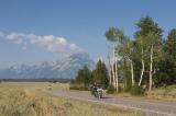
Grand Teton National Park
Grand Teton National Park (String Lake)
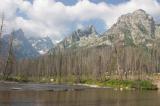
Grand Teton National Park (String Lake)
Grand Teton National Park (Schwabacher Landing)
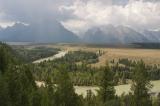
Grand Teton National Park (Snake River Overlook)
Grand Teton National Park (Cunningham Cabin Historic Site)
Grand Teton National Park
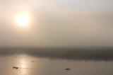
 Early morning fog on the way to Jackson, WY
I woke up before 6am, and was on my way shortly afterwards. I still had some distance to cover before getting into Grand Teton National Park, and wanted to arrive early enough to still get a decent camping spot.
Early morning fog on the way to Jackson, WY
I woke up before 6am, and was on my way shortly afterwards. I still had some distance to cover before getting into Grand Teton National Park, and wanted to arrive early enough to still get a decent camping spot.
There was still some early morning fog, which lifted by the time I arrived in the National Elk Refuge, outside of Jackson, WY; the gateway town to Grand Teton. I didn't see any elk, of course, only some ducks in a pond, so I headed on.
The first glimpse of Grand Teton and its famous mountain peaks was that of a valley bright from sunshine, but mountains dulled by a layer of haze that still persisted. Shortly afterwards, as I got closer, the peaks began to be surrounded by smaller clouds.
I stopped a few times at the turnouts leading to the central part of the park; but didn't waste too much time before heading to one of the campgrounds so I could reserve a camping spot - they are "first come, first served", and I didn't know how many people were visiting at that time of the year.
I went on a quick hike on East Shore Trail, towards Leigh Lake trailhead, then drove the one-way road past Jenny Lake. I had planned to hike around the lake towards Inspiration Point and Hidden Falls, but turned around with the weather and the state of my knees in mind.
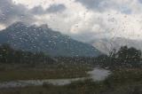
 Thunderstorm going up the valley, temporarily obscuring the Tetons
Instead, I headed to Jackson for lunch, and then returned into the park to drive Hwy 191 along the eastern edge of the park. I first stopped at Blacktail Ponds Overlook, then headed to Glacier View turnout. Meanwhile, clouds had come up from down the valley and/or behind the Tetons, and the sky looked very threatening. I was glad I wasn't still hiking close to the mountains - the rain must have been pretty bad, and there were lightning flashes.
Thunderstorm going up the valley, temporarily obscuring the Tetons
Instead, I headed to Jackson for lunch, and then returned into the park to drive Hwy 191 along the eastern edge of the park. I first stopped at Blacktail Ponds Overlook, then headed to Glacier View turnout. Meanwhile, clouds had come up from down the valley and/or behind the Tetons, and the sky looked very threatening. I was glad I wasn't still hiking close to the mountains - the rain must have been pretty bad, and there were lightning flashes.
I drove on, taking the short detour to meet Snake River at Schwabacher Landing. This would have been a nice spot to photograph the reflections of the surrounding mountains in the surface of the river; if the surface pressure in said river hadn't been broken by rain at that moment, and removed its mirror-like properties. I wondered if I should wait it out, but then decided to move on. I briefly stopped at Snake River Overlook - I decided this would be a nice place to take sunrise photographs the following day.
My next stop was the Cunningham Historic Site - home to one of the pioneer ranches. I spent some time reading the informational leaflet while touring the site, and learned more about the history of the place. It seems that only few of the pioneers were able to make a living with farming in this area - winter was too long and the surface area required to feed one animal tended to be higher than what was available. Still, merely surviving in such a wild setting seems like a remarkable feat to my Western city-dweller eyes, and I was impressed by the idea of anyone tempting the odds, and trying to make his life in a place like this.
Meanwhile, the rain clouds had passed over, and I headed on. I went through the Moran Entrance Station, and my next stop was Oxbow Bend - another spot I mentally filed under "to visit in better light tomorrow morning".
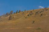
 View from Signal Mountain
I then headed up Signal Mountain Road, a fairly narrow uphill road through a forest, and took in the views of the valley below at Jackson Point. The sun was right behind the Tetons at that time of the day (5pm), so I didn't get any decent pictures facing East and Southeast.
View from Signal Mountain
I then headed up Signal Mountain Road, a fairly narrow uphill road through a forest, and took in the views of the valley below at Jackson Point. The sun was right behind the Tetons at that time of the day (5pm), so I didn't get any decent pictures facing East and Southeast.
The day was nearing its end, and I soon headed back to the Teton Park Road; which in turn took me to Signal Mountain campground, where I spent the night.
Miles driven: 209mi (336km)
![]() Accommodation: NPS Campground (Grand Teton National Park): $12
Accommodation: NPS Campground (Grand Teton National Park): $12