< Previous | List | Next > Hiking around the Last Chance Range, and driving through the Northern part of Death Valley
Click to enlarge!
Death Valley National Park (Last Chance Cabin)
Death Valley National Park (Last Chance Mountain)

Death Valley National Park (Last Chance Mountain)
Death Valley National Park (Last Chance Mountain)
Death Valley National Park (Last Chance Mountain)
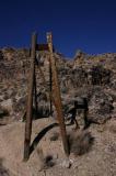
Death Valley National Park (Last Chance Mine)

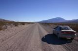
Gently driving my rental Cavalier over a dirt-road. The fall-off to the left is quite scary.
Death Valley National Park (Last Chance Cabin road)

Death Valley National Park (Crankshaft Crossing)
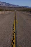
Death Valley National Park (Death Valley Road)
Death Valley National Park (Ubehebe Crater road)
Death Valley National Park (Ubehebe Crater)
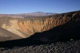
Death Valley National Park (Ubehebe Crater)
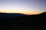
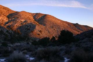 Sunrise on a cold January morning in Last Chance Range in Death Valley National Park
I spent a very cold night in the car next to the remains of the Last Chance Cabin (which had been burned down one or two years before) and started hiking up towards Last Chance Mountain as the sun rose. The contrast of the blue, cloudless sky, the stones illuminated red by the rising sun, and the white snow on the ground was spectacular. I didn't get to enjoy this too much though, for the climb was very steep and after the first few hundred feet, there was no trail anymore; and I merely followed side canyons and ridges.
Sunrise on a cold January morning in Last Chance Range in Death Valley National Park
I spent a very cold night in the car next to the remains of the Last Chance Cabin (which had been burned down one or two years before) and started hiking up towards Last Chance Mountain as the sun rose. The contrast of the blue, cloudless sky, the stones illuminated red by the rising sun, and the white snow on the ground was spectacular. I didn't get to enjoy this too much though, for the climb was very steep and after the first few hundred feet, there was no trail anymore; and I merely followed side canyons and ridges.
As time passed, and temperatures increased, I shed a layer of clothing and continued my climb up some ridge. I'd guess it exceeded 45° a lot of the times, and of course without a trail the best way was straight up. At one point I had to climb around some rocks - the slope had become too steep to just walk around.
This is where I realized how dangerous this kind of thing really was. I was in one of the most remote places in Death Valley, had driven up a side-road that wasn't well-travelled at all, was hiking off established trails; at a time when temperatures during the night went down below freezing. On top of that, the earliest someone would miss me was several days later. This was pure, utter foolishness.
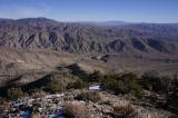
I finally reached a plateau, and was greeted with views (almost) all around. I could see into Eureka Valley, and catch a glimpse of the sand dunes that seemed minuscule in the distance. My original goal, Last Chance Mountain, was still some distance away. By this time my energy levels had gone down, and I was just afraid that if I pressed on, I might do some stupid mistake. So rather than pressing on, I decided to head back down to the car again.
I didn't want to hike down the same way I had gone up (45° incline and loose rock seemed like a recipe for disaster), so I chose to follow a canyon that seemed to head in the general direction of where I was going. The parts that were the least steep were filled with snow, but when faced with the decision to slip down on some loose rocks, or get cold and wet, I chose the latter. I ended up making good progress, even though I sometimes was up to my knees in accumulations of snow.
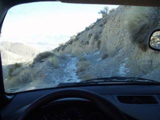 Gently driving my rental Cavalier over a dirt-road. The fall-off to the left is quite scary.
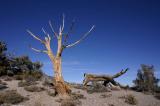
I reached the car, headed back up into one of the canyons to take a few pictures of the nearby mining structures, and then slowly drove down the road again. I think the first two miles took me over half an hour - the road was very rough and a Cavalier clearly didn't have the clearance required on this kind of road...
Gently driving my rental Cavalier over a dirt-road. The fall-off to the left is quite scary.
I reached the car, headed back up into one of the canyons to take a few pictures of the nearby mining structures, and then slowly drove down the road again. I think the first two miles took me over half an hour - the road was very rough and a Cavalier clearly didn't have the clearance required on this kind of road...
Sooner or later, I ended back up at Crankshaft Junction, and was back on the Big Pine road that would lead me further into Death Valley.
I headed south on the Big Pine dirt road - which was painless to drive, with not that much washboard and no bad surprised in the form of washes - stopping for pictures an panoramas every now and then.
I got to Ubehebe Crater just a bit too late - in January, at 3:30pm the sun was already starting to set, and more than half of the crater was covered in shadow.
I took North Highway towards Scotty's Castle, took some sunset pictures along the road, and watched the sun disappear behind the mountains shortly after 4:30pm.
My plan for the night was to head to Beatty, NV; where the first thing I did was to take a long, hot bath.
![]() Accommodation: Motel6 (Beatty, NV): $41.41
Accommodation: Motel6 (Beatty, NV): $41.41
Written 19th December 2004 in Luxembourg, finished May 24th 2005