< Previous | List | Next > Getting a Mount Whitney permit, and hiking the first six miles into it
Click to enlarge!
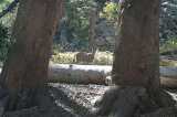
Alabama Hills Recreation Area

Alabama Hills Recreation Area
Inyo National Forest
Inyo National Forest
Inyo National Forest
Inyo National Forest
Inyo National Forest
Inyo National Forest
Inyo National Forest
Inyo National Forest
Inyo National Forest
Inyo National Forest
Inyo National Forest
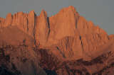
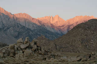 I awoke around 6am, and waited for the sun to rise. Since I'd only arrived after sunset the evening before, I got a first glimpse of the spot I'd chosen as a camp site, and it turns out that it wasn't as bad as I had thought. I was near some of the rocks the Alabama Hills are famous for, and had a direct view of Mount Whitney and the surrounding mountains of the Sierra crest. The first direct sunlight hit Mount Whitney around 6:39am. I took some shots with each of the three lenses I brought, then still drove around for a bit to get a few shots from a different perspective. I left the area around 7:20am, so that I would be at the Interagency Visitor Center south of Lone Pine in time for their 8am opening.
For the Whitney zone, only a limited amount of people are allowed to enter each day. All permits can be arranged in advance, and when I booked my trip and settled on a schedule they were already gone. Fortunately, if people don't pick up their permits they will be made available to walk-ins. This was the case for me, and I got a permit that was valid for an entry the same day, and an exit not more than two days later. As such, I'd have the option of staying either one or two nights on the mountain. Along with the permit, I got a weather report and a waste bag - since there are no toilets beyond the trailhead at Whitney Portal, all "solid waste" needs to be packed out. Or, in other words, instead of digging a hole you're supposed to squat over a plastic bag filled with some chemical agent, and then zip it all up and pack it back out. (Fortunately, I didn't have to use it.)
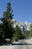
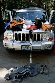 I drove up to Whitney Portal to get a look at the trailhead, found that the store didn't offer much choice in hiker's food; and thus headed back down to Lone Pine to do a quick resupply. While I was at it, I took a shower at the Whitney Portal hostel (clean showers, and the best quality towels I've ever seen in a fee shower). I headed back up to Whitney Portal, and started the annoying process of getting rid of everything that could emit a smell - food, toiletries - from my car and into one of the bear containers. This, along with packing my backpack, took some time. Since I was camping overnight, I had to put all my hiking food into a bear canister that had to go into my backpack. A bear canister is basically a device shaped much like a fat can of your favorite soft drink, except larger; which is closed in such a way that bears can't get to its contents. It adds bulk and weight to the backpack, and my GoLite was barely adequate to fit cold weather gear, full camping equipment, whatever food I needed as well as sufficient water for the trip.
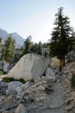
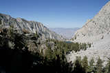
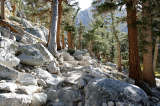
It was also the heaviest pack I've ever had to pack, and when I started up the trail at 1:55pm I could really feel the weight on the shoulder straps. It was still pretty hot outside - the thermometer on the outside of my pack registered a maximum of 30 degrees Celsius. The trail was soft hard-packed sand at first, and it gently increased in elevation over a lot of switchbacks. There were only very few stones or steps, and the trees that still grew at this elevation provided some very welcome shade. There were no other hikers going up that I could see. There were some people with large packs coming down - they looked weary - and some day-hikers who gave (what seemed like) approving glances.
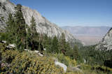
Progress seemed slower than expected, and two times I thought I'd already reached Outpost Camp (3.5mi in) when I hadn't. At around 4:15pm, I finally reached it. And it turns out that this wasn't a bad average considering the temperature, the elevation gain and the weight of my pack. I could have stopped here - only one tent was erected by that time - but still felt I had sufficient energy to get closer to the summit, and reduce the amount of miles I'd have to do the next day.
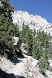
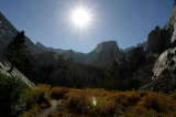
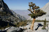
Beyond Outpost Camp, the trail got rockier. At first, there were still isolated trees, but I quickly seemed to head above tree line. The sun wasn't as bad anymore, in fact it would get more and more cold. Once more, I was expecting quicker progress, and the hike just seemed to last for ages. "Trail Camp must be just around the corner" crossed my mind more than once. I did see quite a few potential camp sites, but there was nobody on them at all. While I could have set up camp at any of them, I thought I'd just go with the flow and sleep where everybody slept.
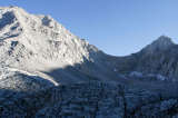
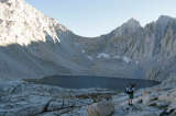
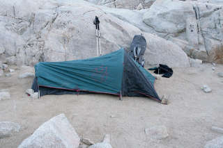 I finally reached Trail Camp at around 5:45pm; and the last 2.5 miles thus took an hour and a half. But then again, this was 12,000 feet already, which was already considerably higher than some of the mountains or passes I'd topped out at in the Alps. I was glad to get rid of my backpack, and looked around for what might be the best spot. I settled on a spot next to an elderly Dutch couple (in their Sixties, presumably) who were doing the John Muir trail and who had been hiking for 21 days now. The spot was soft enough to put my tent stakes in the ground, but it would turn out that it was still quite exposed to the winds that would start blowing quite heavily after midnight.
By 6pm, the tent was all set up. I still took a few last pictures, and then retired into my tent and my sleeping bag, planning to trap as much heat as I could for the night, for the temperatures were expected to be right around freezing during the night.
Miles driven: 49mi (79km)
![]() Accommodation: Trail Camp (Inyo National Forest): $0.00
Accommodation: Trail Camp (Inyo National Forest): $0.00
First part written Friday, 26th September 2008 at my primitive camp site near Overton, NV; while listening to the first presidential debate on satellite NPR; finished 29th September 2008 while wating for the 5pm Halls Crossing Ferry at Glen Canyon, Utah.