< Previous | List | Next > Mariposa Grove; hike from Taft Point to Sentinel Dome via Glacier Point; minor fender scratcher in the valley
Click to enlarge!
Yosemite National Park
Yosemite National Park
Yosemite National Park
Yosemite National Park
Yosemite National Park
Yosemite National Park
Yosemite National Park
Yosemite National Park
Yosemite National Park
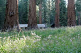
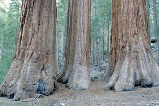 I woke up before 6am. I hadn't slept too well, even though the temperatures never dropped below 15°C. I was on the road before 6:15am. My first destination for the day would be the near , at the southern tip of the park. I arrived before the crowds, and was surprised at how cold it was - much colder than at my camp site. I started hiking at 7:25, when everything was still in shade; going through the Lower Grove and then climbing to the Upper Grove. By the time I reached the museum - 2 miles - I was tired, in both senses of the word: physically and not all that excited about seeing any more trees. As such, I turned around sooner rather than later. Of course I still had to go down the same 2 miles again.
On the way back towards the valley, I wanted to refuel at Wawona, but found what looked like a sudden closure - they were still setting up the cones. I still had plenty of fuel to get me around, but I had been hoping to top off so I wouldn't have to take on as much fuel on the east side of Yosemite later on, where prices would without a doubt be higher still. At the Glacier Point intersection, I got off the main highway and up towards Glacier Point. My first destination was Taft Point, which sits at the end of a small 1.1 mile hike that starts at the same parking than the hike to Sentinel Dome which I had already done during a previous trip.
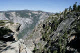
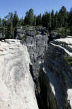
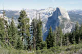
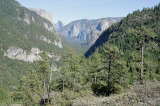
 The 1.1 miles to Taft were quickly covered, and I figured while I was already in that area, that I could get some more hiking in. As it turns out, there was a trail 0.5 miles from Taft Point towards the parking that headed out to Glacier Point, and from there I could get back to my car via Sentinel Dome. Altogether, the hike would be 7 miles; which would be quite doable. I wasn't too concerned about the amount of water in my backpack either: I knew there was a kiosk at Glacier Point where I could "refuel". Taft Point overlooks the lower part of Yosemite Valley: one can see El Capitan and the (dry for now) Yosemite Falls. Half Dome is not visible, and I would get my first glimpse of it maybe half-way into the 2.9 mile hike to Glacier Point. The sky was a perfect blue, with no clouds to be seen, and temperatures were very nice too: perfect T-shirt weather. The trail offered plenty of shade, too: I'd say half of it was under tree cover.
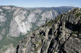
I arrived at Glacier Point at 12:40. The light was not all that great on Half Dome - its sheer face was in shadow, and owing to the mid-day sun all the colors were pretty washed out. But I didn't mind... I already have plenty of good pictures of it. As such, the only ones that I took were those to mark my arrival and departure, to make log-writing easier. At the kiosk, I got something to eat and drink (noticing that the food selection is still as basic as I remembered from past trips), and refueled my energy cells outside the door, a few meters from the overlook. It was interesting to people-watch, too.
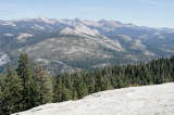
I left about half an hour later, making decent progress on the climb back up towards Sentinel Dome. Once on top of Sentinel Dome - a rock that can be climbed like a baby version of Half Dome (but without any need for cables) - I took a few pictures, and then quickly headed down again for there was a cold wind blowing. From here, it would just be another mile to my car, which I covered quickly.
I'd wanted to stop at Tunnel Overlook next, but to my dismay there was construction going on and the parking lot was closed. If I could have parked there, I'd have hiked up to Inspiration Point or beyond and waited until the sun had gone down a bit to get some good late-afternoon valley overlook shots. As is, I headed back to the valley, looking forward to a shower.
Unfortunately, this wasn't meant to happen. On the stretch of road adjacent to El Capitan, where there's a parking strip on both sides and two lanes going the same direction, I had just passed two cars who were about to park. The next thing I heard was a loud scratching sound. After coming to a stop and getting out, it became evident what just happened: as I was pulling over to the right lane, a car which had been parked on the right parking strip started moving, onto that same right lane. The other car's front left side had touched my right rear side. There wasn't much damage - almost nothing on my car, but some of my plastic had rubbed off onto the other car, and some paint was missing on it. Thankfully, neither tires seemed impacted, nor was there any real dent.
Since both cars were rental cars, and it's better to be safe than sorry with regards to their insurance policies, we (that is, me and the two women in the other car) deemed it safer to call our respective car rental hotlines to report the accident. They followed me to the first spot where I thought there'd be a public telephone within easy reach. They called Alamo to report the incident, and the guy on the phone (who it was difficult to communicate with) suggested we still do a police report. But where would we find police, or rather park rangers in our case?
A woman at the nearby Curry campsite registration desk called them for us, but after a while it became evident that they'd forgotten us. They gave us a number instead, which only yielded an answering machine that said to leave a message (which was useless for us). By this time it was already 6pm, and I suggested we head over to the visitor center since maybe they'd be able to help us. As luck would have it, we came across a park ranger who was finally able to direct us to the right building. To cut a long story short, we ended up with a gun-carrying park ranger, who couldn't do much more than to give us a form that said to report in an office the next morning to get our reports typed up.
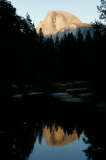
 The other car passengers and me agreed to meet again the next morning at 9am at said office to hopefully get everything sorted out, and then parted ways. I was still able to get some sunset shots on a bridge, before heading back to the pay phone where I did my part of the accident report by calling National and basically repeating what had been said to Alamo before (including the same spell-out-every-letter of our foreign-sounding addresses).
I retired to my camp site, slightly disgruntled that my plan for the next morning (to leave the main valley before sunrise) would have to be postponed by several hours; but still glad that the accident had only been such a minor incident. I told myself that if this was the worst accident I'd be in for the rest of my life, I'd be very glad.
Miles driven: 102mi (164km)
![]() Accommodation: Upper Pines Campground (Yosemite National Park): $20
Accommodation: Upper Pines Campground (Yosemite National Park): $20
Written at Upper Pines campground site 214 on Monday, 22nd September 2008 between 8pm and 9pm.