< Previous | List | Final day in Canyonlands and Arches National Parks
Click to enlarge!


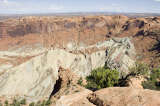
Canyonlands National Park
Canyonlands National Park

Canyonlands National Park

Canyonlands National Park

Arches National Park

Arches National Park

Arches National Park

Arches National Park

Arches National Park

Arches National Park

Arches National Park

Arches National Park
The previous night had been the second-to-last on my trip, and since it was the last one I'd spend in the car I spent some time in the morning packing up my sleeping bags, sleeping mat and just generally tidying up the car and myself. This was aided by the fact that I'd spent the night in a commercial campground, which didn't just have dumpsters to move all my trash to, but also a shower.
After the various cleaning acts had been dealt with, I drove down to Canyonlands National Park; arriving too late in the day to still get decent light in the canyons below. My first stop was at the start of the White Rim road, which I'd driven in 2004 but chose to ignore now because my Buick wasn't really made for that kind of road, and I didn't have the time anyway.
My next stop was a quick hike to ... Arch, a place that is well-known to landscape photographers and regularly draws crowds for sunrise shots. Since it was already later in the day, said photographers were already gone, and the light was considerably flatter than what one would get in the early morning. I still snapped a few shots and told myself I'd be back some other time.
My next stop was for Upheaval Dome Overlook Trail, a short half-mile round-trip hike. I walked around and took pictures, but nothing struck me as particularly inspiring. My next stop, Green River Overlook, was more spectacular, even though the most impressive sights were a few miles off in the distance. Basically, one looks down at one plateau, where large parts of the White Rim road are visible. Next to it, on said white rim, there's another sheer drop to the canyon floor (and many side canyons) with the Green River winding through.
On the way out of the park I saw some animals in the distance. They had horns, but what were they? Bighorn sheep? Sometimes, I wish I knew more about the animal or plant life of the places that I visit. Unfortunately, I mostly got shots of their back sides, since they were steadily moving away from the road and out of view. My final stop was once again at the start of the White Rim road; where I got a few more shots of the road as it winds down to the plateau below. I was jealous at the cars descending - their vacations weren't ending yet, like mine.
My final destination for the day, and the trip for that matter, would be Arches National Park. The sky had turned a nasty gray by this time, and as I drove into the park I could see several thunderstorms surrounding me.
I stopped at Balanced Rock first. I walked around its base, and marvelling at the various impressions one gets - from one side it looks quite sturdy and solid, and from another angle the rock on top looks like it could topple over any moment (which, in geological years could probably be anytime in the next few thousand years).
My next stop was the trail to Landscape Arch. All previous pictures I had of it so far were backlit, since during the day one has to shoot into the sun to capture it. Now, the dark clouds were proving to be a blessing in disguise, because they both filtered out the sun and provided a nice backdrop. The downside was that all those clouds were essentially working like a big soft filter, and as a consequence the colors weren't overly dramatic. But still, I got my best pictures of Landscape Arch so far, and just like Balanced Rock it's a very fragile monument that in the worst case might not even be there anymore when I visit next.
By the time I was back from that short hike, the thunder clouds were getting nearer, and I started to see lightning strikes. This was a sure sign that I shouldn't stray too far from the car anymore - the trails in Arches National Park are exposed to lightning and if crossing some rock one might well be the highest object in the area - not the smartest thing to do in a thunderstorm.
Instead, I stayed close to the car during my next few stops. When I arrived at the Delicate Arch parking, I could see there were still people posing next to the landmark arch. Of course that location is even closer to potential lightning strikes, and it seemed like lunacy to go up there. So instead, I got out my large zoom lens, and took my shots right from the parking lot... a quite touristy thing to do, but safer.
I drove to the Windows section, and here the thunder clouds seemed far enough away for me to hike a little, again. The colours were quite dull, so I didn't get any spectacular photos.
With all the major viewpoints covered, I retreated to my car and drove back to Moab. Here, I decided to stop at a campground and took another shower - my plan was to stay in Moab for the evening, then drive back to Salt Lake City over night, in time for my early morning flight back home. Moab would thus be my last chance to get a shower for the next two days.
After having a final burger dinner, I stocked up on coffee and started the long drive to SLC. Driving through the night wasn't the smartest thing to do; but I've never been prone to falling asleep at the wheel and this way I didn't have to pay for another motel room.
Miles driven: 433mi (697km)
Written Saturday, February 13th 2010 on a Ryan Air flight from Frankfurt-Hahn to Arrecife (Lanzarote)