< Previous | List | Next > Sawtooth National Recreation Area, into Montana, Big Hole National Battlefield, Beaverhead-Deerlodge National Forest
Click to enlarge!
Sawtooth National Recreation Area (Park Creek)

Sawtooth National Recreation Area (Stanley Lake Overlook)

Sawtooth National Recreation Area (Sunbeam Hot Springs)


Beaverhead-Deerlodge National Forest (Grand Vista)

Beaverhead-Deerlodge National Forest (Coolidge)

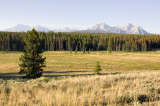
Beaverhead-Deerlodge National Forest

Beaverhead-Deerlodge National Forest (Price Creek Campground)
 After a bit of an uneasy night - primitive camping isn't so great when nature calls in the middle of the night and the nearest amenities are probably miles away - I got up before dawn; and was well on my way as the sun rose over the mountains. I briefly stopped along the road for the obligatory pictures [and failed to note where exactly it was that I took them - I certainly don't remember now, a year and a half later], but they didn't come out as well as I hoped.
Park Creek and Stanley Lake overlooks of the Sawtooth Mountains
My next stop was at Park Creek - an overlook that showcases the mountains of the Sawtooth range. I didn't linger long, because the light wasn't quite right on the mountains. I had better luck a few miles down the road, but not before stopping at Stanley Lake Creek to do a quick wash (hands and face). After that, I felt much better and took the short side road to Stanley Lake Overlook.
On one side of the lake, a bit of steam or fog was still rising from it; while on the other the surface was calm and offered one of the best mountain reflection I've ever seen. I stayed long enough to take both single shots and a handful of panoramas. The main mountain is McGowan peak (or McGown, depending on which information panel to trust), and both it and the lake at the bottom were formed by glacial action. It turns out that McGowan was the rightmost mountain of those that I had seen at Park Creek overlook already.
After a while I headed on, drove through Stanley without stopping, and then came upon Sunbeam Hot springs. This was a fairly unremarkable spot at first: some fumes coming out of a small field of stones at the left of the road; and some hot water entering Salmon River on the right side of the street. Upon closer inspection, there was a small former bath house structure, but it was no longer in use. Nevertheless, one man was enjoying the warm water in the river. Maybe if he hadn't been there I'd have checked it out, but as is I preferred to head on... I'm not sure if I did that more out of respect for the guy, or if it was general paranoia.
I spent the next few hours driving, mostly heading into a Northeastern direction, following the course of the Salmon River. A quarter hour before 2pm, I crossed into Montana via Lost Trail Summit (6995ft).
Big Hole National Battlefield
 After some more driving I found myself at the Big Hole National Battlefield. I stopped more on a whim than anything - I hadn't planned a stop there when I scoured the Internet for interesting spots on my route up to Glacier a few weeks prior. I briefly entered the visitor center, where I briefly chatted with one or two of the rangers (my camera gear raised some comments), and then drove the short distance to the battlefield.
I'm not sure when I came to the realization that maybe I had been misguided in not seeing this place as a potential stop on my route - but I realized that it was foolish to do what I had done earlier on: to discount the place just because it was associated with military action. As a matter of fact, after reading up (thanks to the pamphlets and information panels) on what was an entirely new subject to me I am now seeing this as what it is - an integral part of the area that I'm visiting. As such, it is worth visiting.
Of course, there's not much left of the battlefield, but imagination (based on the information that is provided at Big Hole) can be a good substitute. I also managed to capture what might be my favourite shot of a squirrel - mid-jump, nut in its mouth - even though it's not framed perfectly or as sharp as I'd want it to be.
Pioneer Mountains - Coolidge Ghost Town and surrounding areas
 After a couple of hours, I hit the road again. My next stop were the Pioneer Mountains, and the scenic byway that lead through it. The area is a National Forest, alternatingly called "Beaverhead" and "Beaverhead - Deerlodge" National Forest. I stopped at a few spots - a former homestead, and "Grand Vista", and then drove to the "Coolidge Day Use" area. From here, it was a short half-mile walk to Coolidge. Now a ghost town, it was built around the turn of the 20th century that was built to serve the Elkhorn Mine, located high in the Pioneer Mountains. Its post office was closed in 1932, and since then the town has mostly fallen to pieces. There seems to be no effort to keep any buildings standing, and as such a lot of the structures are in a bad shape. However, that's not necessarily a bad thing per se, since it means that it's a lot more genuine, and there's fewer drive-by tourists.
The sun was already fairly low, so the light was pretty good at first. I wandered through the town (which is (now?) in the midst of a fairly dense forest). After the sun disappeared behind the nearby mountains, I took some more shots in indirect light, spending some time on detail shots of the beautifully aged wood structures and shapes, and then walked back down to my car.
Further down, I was still able to take some more shots in the mostly sunlit-valley, managed to get bitten by a few aggressive mosquitos (there were cattle near by), and then decided to spend the night at the nearby Price Creek Campground, which at $8 was quite reasonable as far as campgrounds go.
Miles driven: 324mi (521km)
![]() Accommodation: Price Creek Campground (Beaverhead-Deerlodge National Forest): $8
Accommodation: Price Creek Campground (Beaverhead-Deerlodge National Forest): $8
First part written on Monday, April 9th 2007 in my apartment; finished on Saturday April 14th.