< Previous | List | Next > Driving to Hole-in-the-rock, then back to Hwy 12; taking Burr Trail into Capitol Reef National Park, and ending up at Goblin Valley State Park
Click to enlarge!

Grand Staircase-Escalante National Monument (Hole-In-The-Rock road)
Glen Canyon National Recreation Area (Hole-In-The-Rock)

Grand Staircase-Escalante National Monument (Highway 12 Scenic Byway)

Capitol Reef National Park
Capitol Reef National Park

Capitol Reef National Park

Goblin Valley State Park
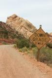
Hole-in-the-rock road
Shortly after sunrise, I was back on Hole-in-the-rock-road, with most of the 57 miles of its length still ahead of me. I made good progress, seeing how the road is mostly flat, and only occasionally crosses washes or other obstructions.
 My rental Chevrolet Blazer right after one of the more challenging parts of Hole-in-the-rock road.
The final six miles were more interesting, and challenging. The terrain changed to slickrock, and for the first time on the trip I had to use the Blazer's four-wheel drive, low gears and high clearance. Now, for a seasoned four-wheeler, the road may not have been all that challenging, but for a city-slicker like me I certainly started sweating (and worrying about damaging the rental car).
My rental Chevrolet Blazer right after one of the more challenging parts of Hole-in-the-rock road.
The final six miles were more interesting, and challenging. The terrain changed to slickrock, and for the first time on the trip I had to use the Blazer's four-wheel drive, low gears and high clearance. Now, for a seasoned four-wheeler, the road may not have been all that challenging, but for a city-slicker like me I certainly started sweating (and worrying about damaging the rental car).
At one or two spots, I actually got out of the car to "spot"... that is, do a visual inspection of the obstacles on the road (trail?) to see if no part of the Chevy would be damaged by going over it, either by missing clearance or by having too much overhang at the front or back. I also pondered if going into the reverse direction wouldn't be a problem - no use making it up some rock if I wouldn't make it back down without damage on my way out.
In the end, I probably worried too much - I made it past the difficult sections without a scratch, or anything worse.
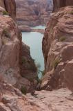
Hole-in-the-rock
 The end of the Hole-In-The-Rock dirt road, and the trail blasted into solid rock by Mormon pioneers
Hole-in-the-rock was created in early 1880 when Mormon pioneers, on one of their treks, encountered a big rocky cliff that they couldn't circumvent. Unwilling to turn around, they spent a sizeable amount of time blasting their way through it to get to the canyon below it, and crossed the Colorado River.
The end of the Hole-In-The-Rock dirt road, and the trail blasted into solid rock by Mormon pioneers
Hole-in-the-rock was created in early 1880 when Mormon pioneers, on one of their treks, encountered a big rocky cliff that they couldn't circumvent. Unwilling to turn around, they spent a sizeable amount of time blasting their way through it to get to the canyon below it, and crossed the Colorado River.
This feat becomes all the more remarkable when looking at the passage they blasted - walking down on foot would be quite a scramble, but descending 26 wagons down there sure shows the determination of the 250 settlers... because there was no easy way they could ever have gone back the same way they came.
Of course nowadays, the canyon floor that they crossed after making it down the "hole" is now covered by Lake Powell, a vast expanse of water created by damming the Colorado River (Glen Canyon Dam) near Page, AZ.
Highway 12, and a disappointing lunch
The 57 miles back to Highway 12 were mostly uneventful, so I was back on paved roads before lunch time. Highway 12 was as scenic as I remembered it, even though it was plagued by at least one vacationer in an underpowered SUV of sorts, who happened to keep on being stuck in front of me with no way to overtake despite me stopping at least once or twice to take pictures.
I wouldn't stay on Highway 12 for very long anyway - I had opted to take Burr Trail into Capitol Reef National Park. Since I hadn't had any decent warm food in a while, I stopped for lunch in Boulder, but was dismayed to find that the burger place we had stopped at in 2001 was closed now. The alternative was more expensive, without that having an impact on the food quality; and the service wasn't very good. Still, I finished with a cup of coffee, which came me by caffeine fix for the day; and I was back on the road.
Burr Trail, and disappointing weather
 Slight overcast on Burr Trail
Burr Trail, for the most part, follows a pretty long canyon that isn't very narrow and bordered on both sides by spectacular rock formations that vary from red to sandstone yellow.
Slight overcast on Burr Trail
Burr Trail, for the most part, follows a pretty long canyon that isn't very narrow and bordered on both sides by spectacular rock formations that vary from red to sandstone yellow.
I had been looking forward to recapture some of the shots I had taken in 2001 - with better gear this time around - but was once again disappointed to find that most of the sky was covered by a very thin cloud cover of almost foggy consistency.
It's still a remarkable place, and I'm looking forward to driving the road again in the future.
Capitol Reef
By the time I entered Capitol Reef, I had become slightly disheartened by the lack of contrast the cloud cover created. What kept me going was my renewed sense of discovery - in 2001, we had been forced to turn around at this point because some genius had managed to become stuck in the Burr Trail switchbacks just a mile or two beyond the park entrance, and we had to turn around.
This time, there was no such incident, and I took a number of nice shots of places I hadn't seen before.
The rest of my time on Capitol Reef wasn't as spectacular - the amount of blue in the sky further decreased, and nothing I saw seemed particularly note-worthy. I followed the road up Waterpocket Fold, heading north to join Highway 24.
At Highway 24, I had to make up my mind - would I enter the main part of Capitol Reef, or head east, leaving it behind? I decided that I would fuel up my car and then reconsider my options. I didn't head back.
Towards Goblin Valley State Park
Instead, I headed on towards Hanksville, where I had a second lunch in the form of burger and fries - much cheaper and better than what I had had in Boulder - and then took Highway 24 North.
 Goblin Valley at sunset
After a somewhat eventless drive, I made it to Goblin Valley State Park. One of the reasons I had chosen this particular spot as my destination for the day is that my Lonely Planet said it had warm showers. Warm showers! Showers!
Goblin Valley at sunset
After a somewhat eventless drive, I made it to Goblin Valley State Park. One of the reasons I had chosen this particular spot as my destination for the day is that my Lonely Planet said it had warm showers. Warm showers! Showers!
After selecting a camping spot and taking that shower, I headed to the main viewpoint of the park, where I spent the remainder of the day taking sunset pictures of the "goblins" - what must be thousands of boulders that are left standing in a valley that must once have been filled with materials of less resistance to erosion... so what remains are these hard round stones standing around in groups or alone, looking much like somebody put them there for one reason or another.
It was at this point that I found back some of the energy that I had been missing throughout the day. Relieved, I drove back the short distance to the campground, still sat outside for a while, looking at the pictures I had taken up until then; and went to sleep in the back of my Blazer.
Miles driven: 258mi (415km)
![]() Accommodation: Camp site 8 (Goblin Valley State Park): $14
Accommodation: Camp site 8 (Goblin Valley State Park): $14
Written March 18, 2005 in Luxembourg