< Previous | List | Next > Hike to Lower Calf Creek Falls; then driving Burr Trail and through Capitol Reef; crossing Lake Powell on a ferry
Click to enlarge!
Kodachrome Basin State Park
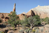
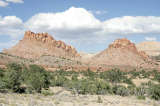
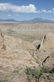
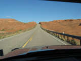
Grand Staircase-Escalante National Monument (Highway 12)
Grand Staircase-Escalante National Monument (Highway 12)
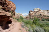
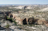
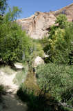
Grand Staircase-Escalante National Monument (Lower Calf Creek Falls trail)
Grand Staircase-Escalante National Monument (Lower Calf Creek Falls trail)
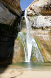
Grand Staircase-Escalante National Monument (Lower Calf Creek Falls trail)
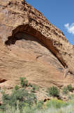
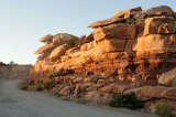
Grand Staircase-Escalante National Monument (Burr Trail)
Grand Staircase-Escalante National Monument (Burr Trail)
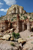
Capitol Reef National Park (Burr Trail)
Capitol Reef National Park (Burr Trail)
Capitol Reef National Park (Burr Trail)
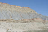
Capitol Reef National Park (Burr Trail)
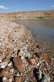
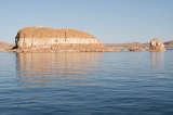
Glen Canyon National Recreation Area (Bullfrog Bay)
Glen Canyon National Recreation Area (Bullfrog Bay)
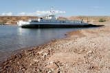
Glen Canyon National Recreation Area (John Atlantic Burr Ferry)
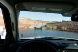
Glen Canyon National Recreation Area (John Atlantic Burr Ferry)
Mokee Dugway
Mokee Dugway
I left my camp site in Kodachrome Basin, opting to not spend any extra time exploring the area, and drove east on Highway 12. I drove past Escalante, and then past the turn-off to Lower Calf Creek Falls, which I didn't realize until a few miles later. Last time I drove past Lower Calf Creek Falls, I decided not to do the hike and then had car trouble later that day. So to appease the Powers That Be of Lower Calf Creek - even though I don't believe any such superstitious thoughts - I thought I'd do the hike this time around. It'd be a nice hike anyway.
 I turned the car around and drove back to the parking lot. With Lower Calf Creek being a popular destination, the parking lot was quite full. I set off hiking quite late in the morning. To make up for the late start, I hiked quite fast; passing quite a few other hikers along the way. The trail wasn't difficult, and since it followed a canyon it was impossible to lose. After about an hour of brisk hiking, interrupted by many quick photo stops, I reached the falls.
They were nice - a creek falling down over stone, various green shades of algae defining the areas where the water hit the rock below and offering a stark contrast to the brown and black of the rock. At the bottom of the falls was a small pool. The clear water was inviting but cold. There were always a handful of hikers around, otherwise I guess some might have been tempted to take a swim. I stayed there for about half an hour, and then hiked back to the car. The temperature at the car was 75 degrees - perfect weather, perfect temperature.
Next up was a drive over Burr Trail, a road that starts off paved and which leads through a canyon with steep rock faces on the north and south side. With the sun still mostly in the south around noontime, and perfect blue skies there were just a few shadows on the north-side rocks. Every few meters there's another spectacularly angled rock, a wall pocketed with hundreds of small holes, or an arch in the making, so the best way to take in the views is to drive down at a leisurely pace with the window open, stopping every hundred meters or so. Thankfully, visibility is good and traffic was very light, so that stopping in the middle of the street did not pose any kind of threat or obstacle to other drivers.
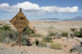
Gradually, the colors of the rock changed - from uniform red to a mixture of all kinds of reds and beige'ish whites. After a while, the road stops being encompassed by rock walls and descends. Then there's yellow warning signs "Down Grade" and the road loses elevation quite steeply down into Capitol Reef National Park. I stopped often on that stretch, but then decided to not venture North into the rest of the park, but rather to head south towards Bullfrog Basin. The road had turned unpaved at the border to Capitol Reef National Park, but it was all well-graded and easily passable by any kind of car. As I continued driving South, I hit pavement again, and among spectacular scenery Burr Trail was soon over and joined Highway 276. And then the highway stopped.
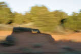
 The reason for this was plain to see: water, and miles of it. I had reached Glen Canyon National Recreation Area, and would need to take the ferry to Halls Crossing - a couple of miles south. The cost was $20. There still was more than half an hour until the next scheduled departure, so I spent that half hour walking around the shore with my camera. As 4pm neared, the cars were guided individually onto the ferry, probably so that there was equal weight distribution. We weren't restricted to the cars, so once the ferry got moving I walked around, taking pictures left and right. After about 20 to 25 minutes, I was on firm ground again and continued east on Halls Crossing Rd. Soon enough, shadows grew longer. I was wondering if I'd be able to capture the shadow of my car on a blur of scenery using a long shutter speed, but getting a sharp shot wasn't easy. I probably shouldn't play around with the camera too much while driving, anyway.
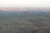
I reached Mokee Dugway just as the last rays of sun hit the rocks, with the plateau below already filled in full shadow. Monument Valley was somewhere beyond, lost in a bit of a haze. I continued down Highway 261, and then took the short Highway 316 east to Goosenecks State Park. Entrance is free, primitive camping allowed, so it was a good spot to spend the night. A Green Tortoise bus with young tourists was parked there as well, which marks my first encounter with that mode of vacationing which I'd read about maybe as much as ten years ago when I first looked into US trips.
Miles driven: 241mi (388km)
![]() Accommodation: Goosenecks State Park (Primitive camping): $0.00
Accommodation: Goosenecks State Park (Primitive camping): $0.00
Written 19/Feb/2011 in Esch-Alzette