< Previous | List | Next > Hiking up Eureka Sand Dunes, more hiking in Eureka Valley; and a drive up to Last Chance "cabin".
Click to enlarge!

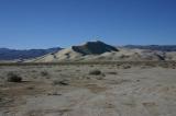
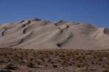
Death Valley National Park (Eureka Sand Dunes)

Death Valley National Park (Eureka Sand Dunes)

Death Valley National Park (Eureka Sand Dunes)
Death Valley National Park (Eureka Sand Dunes)
Death Valley National Park (Eureka Valley)

Death Valley National Park (Eureka Valley)

Death Valley National Park (Eureka Valley)

Death Valley National Park (Eureka Valley)
Death Valley National Park (Eureka Valley)

Death Valley National Park (Eureka Valley)

Death Valley National Park (Death Valley Road)
 I woke up to ice on the inside of the car, again. The night had not been all that much fun because I was just too cold - I hadn't brought a sleeping bag with me from Luxembourg, so R loaned me hers, which wasn't really adequate for the cold I encountered. I ended up sleeping fully clothed, with the sleeping bag, a blanket and whatever else I could find on top of me. For most of the night, I was wearing a scarf and a fleece cap, so the only thing in my face that was uncovered were my eyes. And I was still cold.
As such, I was only too happy to get up even before the sun did - and in fact, that had been my plan all along: to greet the sun on the top of the Eureka Sand Dunes just as it rose over the surrounding mountain range.
Somewhere between 7am and 8am - I don't really know the exact time because my two digital cameras were off by over a half hour, so I don't know which one to trust - the first hues of red were visible across the valley. After a strenuous climb, I still made it to the top of the dunes before seeing the sun, but didn't have much time to spare.
 I had brought along my 8lbs tripod, and set it up on top of the highest sand dune so I'd be able to take panoramas. I took a few as the sun had reached the optimal position: that is, high enough to illuminate most of the dunes in warm colours, but still low enough to produce dramatic shadows and not wash everything out in too much light.
The panoramas didn't turn out too bad - one was printed in a German magazine in early 2005. (All I won was a yearly subscription to it - but I'm taking small steps with my photography, and this was a good first step, I guess.)
I still stayed at the top of the dunes for a while. It was still fairly cold, but that would soon change. At around 10am, I set out for a hike that would take me up an alluvial fan, to what looked like the mouth of a canyon. The incline was very gradual, and didn't look that exhausting at first, but I quickly broke out a sweat and started getting rid of one layer of clothing after the other. Being able to walk in just jeans and a t-shirt was a nice change from the early morning, when I couldn't find enough clothing layers to keep warm.
After about an hour and 45 minutes later, I reached the mouth of a wide canyon, and was dismayed to find that I had gone through my water much faster than I had anticipated when starting the hike - less than half of it was left, and I didn't feel comfortable heading on much more, because that would have meant not having any water on the way back down.
After taking a break and walking around the immediate surrounding to take more pictures, I headed downhill again. I wasn't able to faithfully retrace my steps, so I ended up following washes while heading into the general direction of my car which I could still see in the distance. On my way uphill, I had not seen any of these washes - in fact the surface had seemed pretty smooth.
Not surprisingly, walking downhill was much faster than the first part of the hike, so I was back at the car before 2pm.
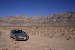 My rental Chevrolet Cavalier on a dirt road in Eureka Valley, in Death Valley National Park
I still followed the dirt road leading to Steel Pass for a while, but after a couple of miles decided that the road really wasn't appropriate for my 2WD sedan anymore. This short diversion ate up almost an hour of my time, and I found myself heading back north on Eureka Road, back to Big Pine Road. There were one or two more cars parked at the base of the dunes now, and a couple in a truck going towards Steel Pass asked if I had come into the valley that way - I had to admit I didn't.
My rental Chevrolet Cavalier on a dirt road in Eureka Valley, in Death Valley National Park
I still followed the dirt road leading to Steel Pass for a while, but after a couple of miles decided that the road really wasn't appropriate for my 2WD sedan anymore. This short diversion ate up almost an hour of my time, and I found myself heading back north on Eureka Road, back to Big Pine Road. There were one or two more cars parked at the base of the dunes now, and a couple in a truck going towards Steel Pass asked if I had come into the valley that way - I had to admit I didn't.
Back on Big Pine Road road, I drove through Hanging Rock Canyon, and approached the Crater Mine. For a short stretch, I was able to enjoy a paved road again - after all the washboard, this was a nice change.
Soon enough, I was back on dirt roads though, and as the shadows started to grow longer already, I reached the start of the main valley - I was finally in the real Death Valley, almost a day after crossing the park boundary. I stopped for pictures at what has now become a regular spot - I've got pictures of three different rental cars parked at a pullout that affords the very first view into the valley.I reached Crankshaft Junction after it was already covered in shadows - it wasn't even 4pm. I decided that I would need to find a good camping spot for the night, and thought "why not" on heading up on Last Chance Cabin road, a short dead-end road heading to the very top of the valley. At this point, I didn't yet know that Last Chance Cabin no longer existed - the book on Death Valley that I had still mentioned it, and it wasn't that old..
The road was very demanding on my small rental car. It was a narrow one-lane dirt road, with a fairly high protrusion of stones in the middle of the lane. On a high-clearance vehicle, this wouldn't have been much of a problem, but on my Cavalier this meant I came close to scratching the oil pan.
It took me around 45 minutes to drive just slightly more than two miles. And as I arrived at the end of the road, I discovered that Last Chance Cabin was no more - it looked like it had been burned down not too long ago.
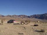
I didn't care much, and after setting up my sleeping pad and bag in the trunk of the car and reading for a while, I called it a night. I was hoping that it wouldn't get as cold as the night before, but unfortunately, it did.
![]() Accommodation: Near the remains of the Last Chance Cabin (Death Valley National Park): $0
Accommodation: Near the remains of the Last Chance Cabin (Death Valley National Park): $0