< Previous | List | Next > Grand Canyon and Bryce Canyon: Failed plans and photographic opportunities in Arizona and Utah
Click to enlarge!
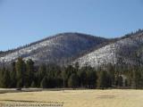
Flagstaff, AZ
Grand Canyon National Park
Grand Canyon National Park
Highay 89A
Highay 89A
Bryce Canyon National Park
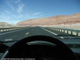
 Random shot taken on the road from Flagstaff to Grand Canyon National Park
After a late start (8:30am), I departed from Flagstaff, taking Highway 180 North. This took me through scenic Coconino National Forest first, then into Kaibab National Forest as I approached Tusayan; which is nothing more than a few motels and restaurants catering for the many Grand Canyon tourists. And many Grand Canyon tourists, there were. I was at the rim in little less than two hours after my departure from Flagstaff - I was driving the speed limit, stopped once for photographs, and had trouble finding a parking spot.
Random shot taken on the road from Flagstaff to Grand Canyon National Park
After a late start (8:30am), I departed from Flagstaff, taking Highway 180 North. This took me through scenic Coconino National Forest first, then into Kaibab National Forest as I approached Tusayan; which is nothing more than a few motels and restaurants catering for the many Grand Canyon tourists. And many Grand Canyon tourists, there were. I was at the rim in little less than two hours after my departure from Flagstaff - I was driving the speed limit, stopped once for photographs, and had trouble finding a parking spot.
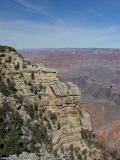
And I wasn't disappointed. I'm not sure if it was the morning sun, the cold air, or some other reason; but Grand Canyon looked just so much better than last year. The air was a clear blue, the North Rim was clearly visible with no apparent pollution or haze in the canyon, and the colors seemed just so much more vivid.
Also a major surprise was the Colorado's color: clear blue, rather than last year's muddy brown.
I promptly took many photos and attempted two panoramas, all the while wondering how it could possibly be that I was the tourist with the most advanced photo gear. There were many stereotypical tourists quite obviously just stepping out of their luxury cars or overkill pickups. Loud exclamations of how "wonderful" it all is were abundant. All this before snapping one or two pictures with their cheap point-and-shoots, not caring about framing the shot and preferring to focus on their offspring in the middle of the picture rather than what they came for (or should have come for).
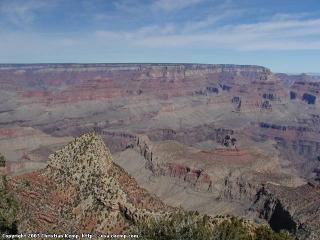 Looking into the Grand Canyon
But then again, I wasn't much better than they were. After taking the aforementioned photographs, I opted not to hike down into the canyon (citing time constraints and telling myself how it was already too late in the day to cover any significant distance). Instead, I told myself I'd just head west, then north towards the North Rim.
Looking into the Grand Canyon
But then again, I wasn't much better than they were. After taking the aforementioned photographs, I opted not to hike down into the canyon (citing time constraints and telling myself how it was already too late in the day to cover any significant distance). Instead, I told myself I'd just head west, then north towards the North Rim.
Overall, I stopped at Mather Point, Yavapai Point and Grand View Point; although at the time of writing this I cannot remember a lot of specifics for each of them.
But perhaps I should have investigated further before jumping to route conclusions. As I discovered later on, the North Rim was obviously closed for winter. And me being the fool I am just didn't think for a moment that March could still be considered winter.
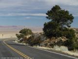
But first came the drive towards Bitter Springs, AZ, where an alternative Highway 89 branches east to cross the Colorado at Navajo Bridge. Before this intersection, a lot of distance needs to be covered in Navajo land, and the scenery is fairly spectacular, albeit all the driving gets tiring after a while. Also, if you're moving along at 65 miles per hour, it's difficult to photograph interesting rock formations. Especially if you're on a fairly tight schedule and cannot really stop every few miles for pictures. That, and it is not always practical, or even possible, to get off the road for a quick stop.
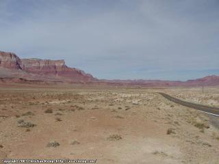 Random shot along Highway 89A
Nevertheless, the route is spectacular (and I guess I should really start using a thesaurus). I'm sure the drive to the North Rim would also have been nice, but alas it wasn't supposed to be,
Random shot along Highway 89A
Nevertheless, the route is spectacular (and I guess I should really start using a thesaurus). I'm sure the drive to the North Rim would also have been nice, but alas it wasn't supposed to be,
Instead, I decided on the road that I would just drive north into Utah. And suddenly, I was determined to make it to Bryce Canyon in time for sunset pictures.
Which explains that suddenly, there are no more pictures for a long time. I was just concentrating on driving, and yes, I admit, drove just a little bit over the speed limit.
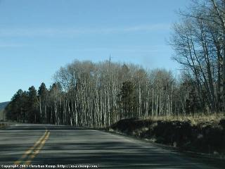
I'm not sure why I had suddenly become so obsessed with the Bryce sunset idea. The drive up Highway 89 in Utah, between Kanab and just before Panguitch was positively magic. The sun had already begun to set, and there were so many scenes that I caught a glimpse of and thought they were worth a picture. Or two. Now that I think of it, I really should have stopped. Taken that picture of a tree. Or a stream floating calmly in the afternoon light. So many wasted opportunities.
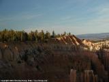
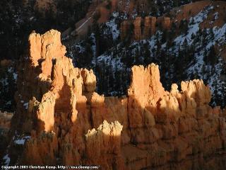 Sunset in Bryce Canyon National Park
But in the end, I arrived in Bryce Canyon just in time for the last rays of sun. And all these photographs not taken were forgotten when I saw the hoodoos (Bryce's rock formations), half in shadow, half in bright sunlight; in all possible colors from brown over red to white; some still covered in snow, all under an interesting sky (partial clouds). And I took many pictures. (A recurring theme, I know.)
Sunset in Bryce Canyon National Park
But in the end, I arrived in Bryce Canyon just in time for the last rays of sun. And all these photographs not taken were forgotten when I saw the hoodoos (Bryce's rock formations), half in shadow, half in bright sunlight; in all possible colors from brown over red to white; some still covered in snow, all under an interesting sky (partial clouds). And I took many pictures. (A recurring theme, I know.)
It was great. I'm fond of some of the pictures I took. The solitary photographer. The couple standing on the cliff, looking into the distance (visibility was awesome).
And then day turned into night, and I drove into nearby Tropic for a good night's sleep.
Miles driven: 388mi (624km)
![]() Accommodation: Country Inn Motel (Tropic, UT): $38.85
Accommodation: Country Inn Motel (Tropic, UT): $38.85
Written on September 14th 2002 at around 8pm in Luxembourg, after spending most of my afternoon on planning my next, upcoming, US trip.