< Previous | List | Next > Heading into Idaho, hiking in City of Rocks, getting lost on the backcountry roads south of Snake River
Click to enlarge!


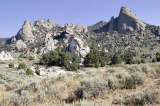
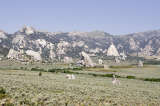
City of Rocks National Reserve
City of Rocks National Reserve

City of Rocks National Reserve
City of Rocks National Reserve


Twin Falls, ID (Perrine Bridge)


With a lot of my shopping done the day of my arrival already, I was ready to head north straight away. As such, I didn't waste much time checking out of my Motel6 room, and was on the Interstate shortly after 7am, on my way out of Utah.
 Less than an hour later, I crossed the Idaho state line, which was also my first short stop for the day. Just a few miles later, I stopped again, at a spot that my AAA map identified as "Strevell" ghost town. Apart from one house and a few foundations, I didn't see much, and even that wouldn't have been worth any kind of detour. Fortunately, I hadn't taken any detour, since I was on my way towards City of Rocks. Beyond Strevell, I had to turn off the highway and onto a dirt road - albeit a well-graded one. Shortly after 9am, I arrived in City of Rocks, a "National Reserve" (which, as I understand, means it's not unique enough to be called "national park" or "monument").
At around 10am, and after one or two short picture stops, I parked the car and got out the tripod for a few more serious panoramas; and then went on a hike, starting from the Lower North Fork Circle Crek trailhead. The hike didn't take all that long (I didn't follow the trail to its end), and I was back at the car slightly over an hour later.
I explored the rest of the park in my car, only briefly stopping at a few spots to take pictures. I left at noon.
Southern Idaho is fairly empty and barren, and more than once I saw old cars rusting away in a field next to the road just because that is apparently the easiest solution of "disposal". This has the advantage that after twenty or more years of being "trash" an abandoned car suddenly becomes a "photo stop", because elsewhere cars from the Fifties or Sixties are hard to find and here they can be seen (albeit in a pretty bad shape) just next to the road.
I rejoined the pavement in Twin Falls, Idaho. I crossed the Snake River on Perrine Bridge, and then headed on to Hagerman Fossil Beds National Monument. I failed to see the appeal of this small park - which in fairness is probably saying more about me than it does about the park - and as such was itching to move along pretty soon.
My destination for the day was Bruneau Sand Dunes, a state park where I was intending to camp that night. The closest route was to take me over unpaved roads. (A decision that I would later on regret - but let's keep quiet about the specifics of that, shall we?) Initially, the dirt roads were fairly wide; but gradually they got narrower, had treacherous bends and some of them just ended at a gate... Seeing how I wasn't sure if the gate belonged to a gun-swinging, trigger-happy cowboy type or just someone intent on not letting his cattle get away, I preferred to turn around and take alternative roads. DeLorme StreetAtlas and a GPS helped a lot, but then again, they were responsible for getting me to those gates in the first place.
At the end of the day, after some minor despair and some major swearing, I made it east to Bruneau Sand Dunes. Unfortunately, the sun set when I was still driving; and I only arrived at the dunes past sunset. There was nothing much for me to do but set up my sleeping pad and bag in the back of the Jeep, and try to get a good night's rest.
Miles driven: 429mi (690km)
![]() Accommodation: Bruneau Sand Dunes (Bruneau, ID): $16
Accommodation: Bruneau Sand Dunes (Bruneau, ID): $16
First part written 21 October 2006 at gate E77 in Paris CDG. Partially updated 28 January 2007 in Hooglede, Belgium; finished 31 January 2007 at home in Bivange, Luxembourg.